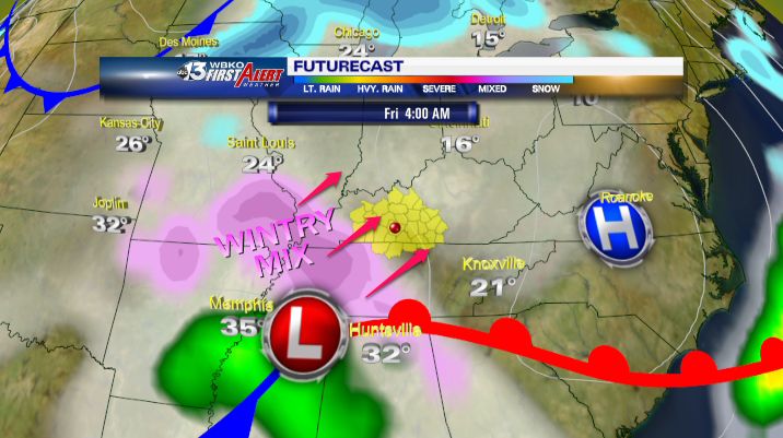
Latest indications project a mix of rain/sleet/freezing rain and snow will arrive early Friday morning – specifically after 4am in the Bowling Green area. As the precipitation falls, it will freeze on surfaces – including roadways – which will be below freezing (32°) causing hazardous driving conditions for the morning commute.
NOWCAST:
Mainly clear with a few clouds at times this morning. Temperatures will remain in the 30s.
DRY BUT COOLER
After a nice warmup Wednesday, another shot of cooler air arrives tonight into Thursday behind a weak front slipping through. We should have lots of sunshine again today but northeast winds will keep temperatures from warming much above the freezing mark…about 15° colder than Wednesday. Clouds increase this evening, with readings dropping into the 20s.
WINTRY MIX EARLY FRIDAY
An area of low pressure moves out of the Southern Plains and into the lower Tennessee Valley early Friday. This spreads moisture into South-Central KY with warmer air riding over colder air at the surface, resulting in a mixed bag of precipitation. With readings in the upper 20s, expect a mix of snow, sleet, and freezing rain to develop around daybreak Friday morning. Whatever falls should be light, but the timing of the precipitation’s arrival could result in some slick travel Friday morning – particularly on bridges and overpasses as well as less-traveled roads. The wintry mix should move out around midday Friday with mostly cloudy and cold conditions into the afternoon. Highs should reach the mid 30s.
THE WEEKEND AND BEYOND
The weekend begins dry and cold before a warmer but wetter pattern takes shape for Sunday into midweek. Periodic chances for showers are in the forecast through that period, with highs climbing from the chilly 30s Saturday into the balmy lower 60s by Tuesday. A cold front is slated to move through the area late in the period with falling temps Wednesday afternoon.
TODAY:
Partly Sunny, Colder… High 32, winds NE-8
TONIGHT:
Cloudy, Winter Mix After Midnight…Low 26, E-6
Precip Ch. 60% – Around 0.10″ Rain/Freezing Rain/Sleet/Snow
FRIDAY:
Winter Mix Likely…High 36, W-11
Precip Ch. 70% – Around 0.10″ Rain/Freezing Rain/Sleet/Snow
